2021 Projects
- ATCorp
- Adventium Labs
- BCBSND
- BlenderRender
- Bushel
- CHAPS
- CSAIA
- Collins
- Inwerken
- John Deere
- Marvin
- Microsoft
- NAU
- Noridian
- OpenStack
- Pedigree
- Potlatch
- Scheels
- UGPTI
2020 Projects
- Adventium
- Aeritae
- Appareo
- BCBS
- Barginns
- Border States
- Botlink
- Bushel
- Capturis
- Collins
- Inwerken
- John Deere
- Marvin Windows
- Microsoft
- Nau Country
- Noridian
- Openstack
- Pedigree
- Scheels
- TBD(Deakin)
- UGPTI
2019 Projects
- ATC
- Adventium
- Aeritae
- Barginns
- Border States
- Capturis
- Collins
- Deakin
- Fjorge
- ICPE
- Integrity
- Microsoft
- Myriad Mobile
- NDSU CS
- Nau Country
- Noridian
- Omnibyte
- Openstack
- Pedigree
- Scheels
- Software Center
- UGPTI
2018 Projects
- ATC
- Adventium
- Aeritae
- Appareo
- Border States
- Capturis
- ControTech
- Fjorge
- Inwerken
- John Deere
- Microsoft
- NDSU Music
- Next
- Noridian
- OmniByte
- OrbitalATK
- Pedigree
- QBE NAU
- Rockwell Collins
- Software Center
- UGPTI
2017 Projects
- Adventium
- Botlink
- Data61
- Ericsson
- FBS
- Fjorge
- Humach
- IBM
- Integrity
- Intelligent Insights
- Inwerken
- John Deere
- Microsoft
- Mindroad
- Noridian
- Pedigree
- QBE NAU
- Sanford
- UGPTI
- Valley Express
2016 Projects
- ATC
- Adventium
- Bolder Thinking
- Capturis
- Data61
- FBS
- Fjorge
- IBM
- Integrity
- Inwerken
- John Deere
- Linkoping SMHI
- Microsoft
- NDSU IT Dept
- Noridian
- Rockwell Collins
- UGPTI
- Valley Express
2015 Projects
- ATC
- Adventium
- Bolder Thinking
- CNE
- Capturis
- Ericsson
- IBM
- Inwerken
- John Deere
- Microsoft
- NICTA
- Rockwell Collins
- UGPTI
- Valley Express
2014 Projects
- Bolder Thinking
- CNE
- FBS
- IBM
- Inwerken
- John Deere
- Microsoft
- NISC
- Rockwell Collins
- UGPTI
- Valley Express
2013 Projects
2012 Projects
- ATC
- Air Academy
- Bolder Thinking
- Combridge
- Douglas Scientific
- FBS
- IBM
- Microsoft
- NDSU CS (Denton)
- NDSU CS (Kong)
- NDSU CS (Walia)
- NISC
- Phoenix International
- RDO
- Rockwell Collins
- Syntronic
- UGPTI
2011 Projects
Agri ImaGIS: Satshot iPhone Application
Project Details
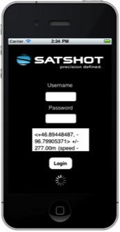

Based out of North Dakota Agri ImaGIS provides a focus on satellite imagery and data analysis for agricultural business and the crop insurance industry. With Mapcenter v2.0 and Satshot 3D products already available Agri ImaGIS looked to expand to the iPhone market.
Features:
- User access by Login and Logout
- Location fetched by GPS
- Load and Display map images of fields within 500 meters
- Allow user to select from list of satellite scenes
- Pass zone information to server and display results of image analysis.
- User is able to take and upload geo-tagged pictures with comments