2021 Projects
- ATCorp
- Adventium Labs
- BCBSND
- BlenderRender
- Bushel
- CHAPS
- CSAIA
- Collins
- Inwerken
- John Deere
- Marvin
- Microsoft
- NAU
- Noridian
- OpenStack
- Pedigree
- Potlatch
- Scheels
- UGPTI
2020 Projects
- Adventium
- Aeritae
- Appareo
- BCBS
- Barginns
- Border States
- Botlink
- Bushel
- Capturis
- Collins
- Inwerken
- John Deere
- Marvin Windows
- Microsoft
- Nau Country
- Noridian
- Openstack
- Pedigree
- Scheels
- TBD(Deakin)
- UGPTI
2019 Projects
- ATC
- Adventium
- Aeritae
- Barginns
- Border States
- Capturis
- Collins
- Deakin
- Fjorge
- ICPE
- Integrity
- Microsoft
- Myriad Mobile
- NDSU CS
- Nau Country
- Noridian
- Omnibyte
- Openstack
- Pedigree
- Scheels
- Software Center
- UGPTI
2018 Projects
- ATC
- Adventium
- Aeritae
- Appareo
- Border States
- Capturis
- ControTech
- Fjorge
- Inwerken
- John Deere
- Microsoft
- NDSU Music
- Next
- Noridian
- OmniByte
- OrbitalATK
- Pedigree
- QBE NAU
- Rockwell Collins
- Software Center
- UGPTI
2017 Projects
- Adventium
- Botlink
- Data61
- Ericsson
- FBS
- Fjorge
- Humach
- IBM
- Integrity
- Intelligent Insights
- Inwerken
- John Deere
- Microsoft
- Mindroad
- Noridian
- Pedigree
- QBE NAU
- Sanford
- UGPTI
- Valley Express
2016 Projects
- ATC
- Adventium
- Bolder Thinking
- Capturis
- Data61
- FBS
- Fjorge
- IBM
- Integrity
- Inwerken
- John Deere
- Linkoping SMHI
- Microsoft
- NDSU IT Dept
- Noridian
- Rockwell Collins
- UGPTI
- Valley Express
2015 Projects
- ATC
- Adventium
- Bolder Thinking
- CNE
- Capturis
- Ericsson
- IBM
- Inwerken
- John Deere
- Microsoft
- NICTA
- Rockwell Collins
- UGPTI
- Valley Express
2014 Projects
- Bolder Thinking
- CNE
- FBS
- IBM
- Inwerken
- John Deere
- Microsoft
- NISC
- Rockwell Collins
- UGPTI
- Valley Express
2013 Projects
2012 Projects
- ATC
- Air Academy
- Bolder Thinking
- Combridge
- Douglas Scientific
- FBS
- IBM
- Microsoft
- NDSU CS (Denton)
- NDSU CS (Kong)
- NDSU CS (Walia)
- NISC
- Phoenix International
- RDO
- Rockwell Collins
- Syntronic
- UGPTI
2011 Projects
Data61: Itenerary Visulization on Australia's National Map
Project Details
Team Members
- Rachelle Clayton
- Jordan Christiansen
- Joseph Osborne
- Sean Warne
Poject Description
The National Map is a project developed by National Information Communication Technology of Australia (NICTA). Data61, the largest data innovation group in Australia, was formed by merging NICTA and CSIRO. National Map takes data from data.gov.au, an Australian government website, and visualizes it on the map. As of now, National Map does not allow users to create and view routes.
Our task was to make an application for tourists to plan trips. We chose to visualize multiple routes on the map so tourists could decide which route from a point A to a point B suited them best. We decided upon different criteria to rate the routes. These criteria include time, distance, and beauty. Each quality criteria are to be visualized on the map in a different way. The user could then decide which route suited them best. We also connected data on points of interest from multiple sources. We pulled pictures from Flickr that would highlight attractions along each route. This will help a user decide which route they found more interesting.
We were able to accomplish most of the tasks we set out to accomplish from the beginning. We were able to pull in data from Flickr and view it on the map as points. We were also able to rate each route based upon the distance. We decided to visualize them with different color lines and different weights for the ranking. The thicker the line, the better that route is for that attribute.
Here is a screenshot of the lines with different weights and colors:
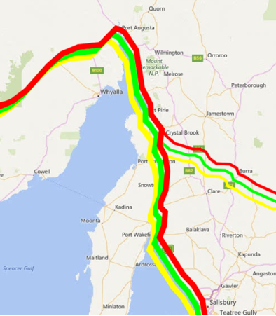
You can see the higher route has thinner lines and the lower route has thicker lines. This is one way you can visualize the difference between the two routes. Of course, there are many other possibilities for visualization.
We really enjoyed working with an international company and gained some valuable experience. This Capstone project provided us with many opportunities we would have otherwise not had access to. We hope Data61 can improve upon our visualization techniques and eventually use our ideas in Australia's National Map.